What Were the Sea Conditions During the KM Putri Sakinah Accident?
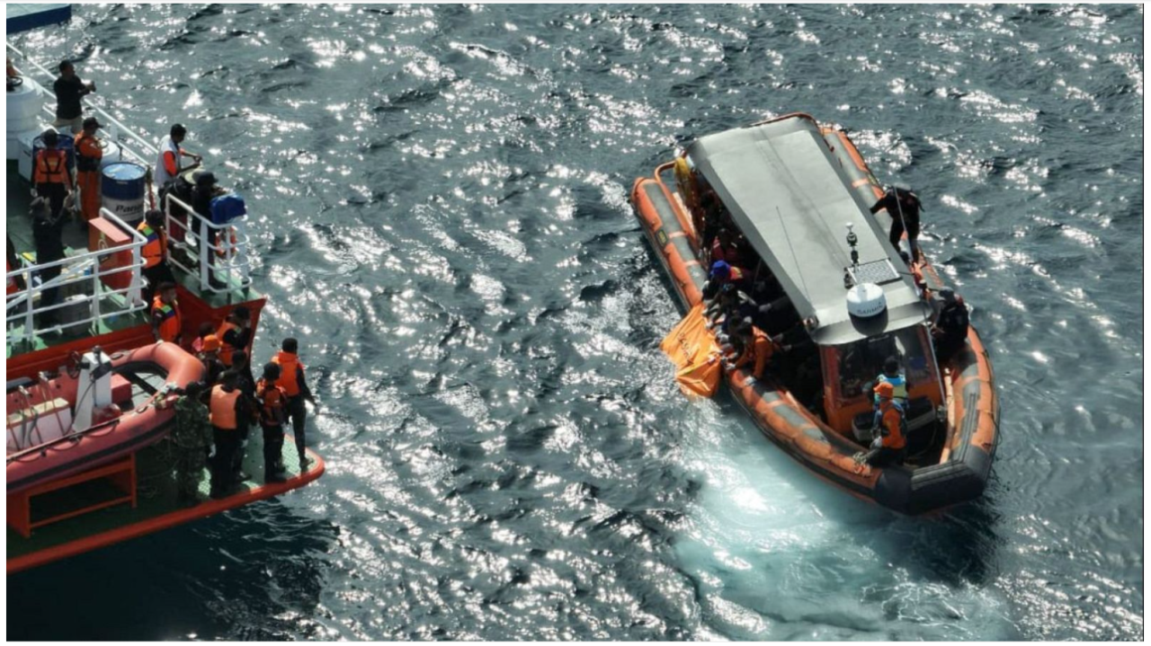
An Independent Metocean Analysis of Labuan Bajo
1. The Incident: What Happened in Labuan Bajo?
On 26 December 2025, during the Christmas and New Year holiday period, a tragic maritime incident involving KM Putri Sakinah occurred in the waters of Labuan Bajo, Indonesia. The vessel was operating in one of Indonesia's most prominent marine tourism destinations, an area visited by thousands of domestic and international tourists each year.
Reports surrounding the incident highlighted adverse weather and sea conditions among the factors requiring consideration. This raises an important question from a metocean perspective:
"What were the actual environmental conditions around Labuan Bajo when the incident occurred?"
Monsun examined prime marine weather parameters — wind, waves and ocean currents — surrounding the incident to understand how the marine environment evolved before and during 26 December 2025.
This is an independent metocean assessment, not an accident investigation. It does not seek to determine the official cause of the sinking or assign responsibility to any party.
2. Labuan Bajo: A Calm-Looking Sea Can Be Complex
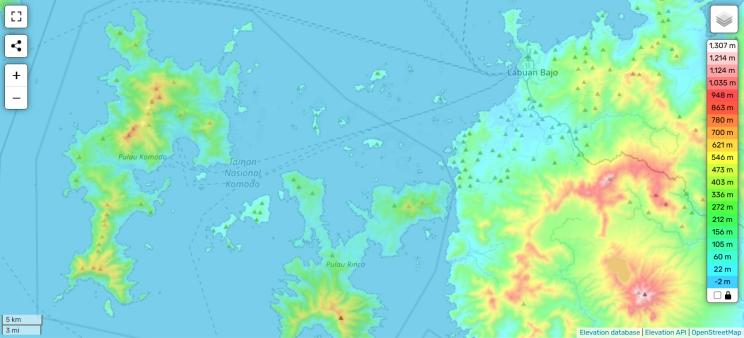
At first glance, the waters around Labuan Bajo, Padar and Komodo can appear relatively sheltered. The area is surrounded by islands, narrow passages and relatively protected waters. On the other side, this geographical complexity also makes the local marine environment difficult to interpret from regional weather information alone.
The waters around Labuan Bajo are influenced by the interaction of wind, waves, tides, ocean currents, islands and bathymetry geometry. Strong regional winds do not necessarily produce equally large waves everywhere. Likewise, ocean currents can accelerate, change direction and interact with the complex geometry of narrow channels. This is why a marine environment that appears calm from the shoreline may still contain environmental conditions that are important for vessel operations.
For this analysis, Monsun examined the period from 23–30 December 2025, covering several days before and after the incident, utilizing the hindcast dataset from GFS by NOAA.
3. What Did the Metocean Data Show?
Monsun analyzed meteorological and oceanographic data covering the period surrounding the incident, focusing on three primary parameters: wind, waves and ocean currents.
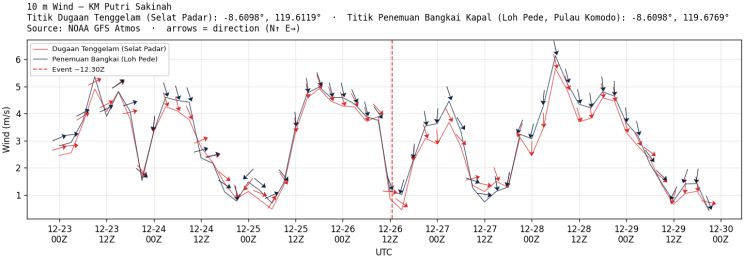
Wind: Not an Extreme Signal
Wind speeds around the study area generally ranged from approximately 0.5 to 6 m/s, with noticeable daily fluctuations. The typical day-by-day wind speed ranged around 1 or 2 m/s to 4 or 5 m/s.
During 23–25 December 2025, the data showed a recognizable diurnal pattern, consistent with the influence of local land-sea breeze circulation. Winds generally changed between nighttime and daytime as the land and sea responded differently to solar heating.
Around 26 December 2025, however, this regular pattern became less distinct. While the wind conditions were changing, the observed wind speeds alone do not indicate an exceptionally extreme atmospheric event during the incident window around 26 December 2025 12:00 UTC.
Waves: Relatively Modest Significant Wave Height
Significant wave and primary swell height around the study area generally remained below approximately 0.5 m during 23–27 December 2025 — Smooth seas and swell on a Douglas Scale adaptation of sea state.
A temporary increase occurred on 24 December 2025, when significant wave height increased from approximately 0.2–0.3 m to 0.4–0.5 m within less than 12 hours. Wave height increased again around 26 December 2025, reaching approximately 0.4–0.5 m. In general, these values of wave height may not be driving a vessel to capsize.
As an important understanding, these values of significant wave height should not automatically be interpreted as extreme sea conditions, since significant wave height represents a statistical description of the sea state and does not represent 100% of the maximum individual wave in the sea.
Current: The More Interesting Signal
The ocean current presents a different picture.
During most of 23–30 December 2025, the current exhibited a recurring pattern associated with tidal cycles, with alternating flood and ebb phases.
On 26 December 2025, however, the current behaviour differed from the surrounding days. Current velocity remained relatively persistent at approximately 0.5–0.6 m/s, or around 1–1.2 knots, while the current direction changed noticeably over a relatively short period.
The change in direction is particularly interesting because current magnitude alone does not describe the full hydrodynamic environment. In narrow or island-dominated waters, current direction relative to a vessel's heading and local bathymetry can also be operationally important.
4. So, Was the Weather Really the Problem?
Based on the parameters examined, the environmental picture is more complicated than simply describing 26 December 2025 as an "extreme weather event". A more comprehensive investigation of accurate and precise current speed around Padar–Labuan Bajo waters would be significantly valuable.
The wind speeds and significant wave heights identified in the analysis do not, by themselves, indicate an exceptionally severe regional storm. Instead, one of the more notable signals appears in the ocean-current behaviour.
Around 26 December 2025, the current showed a departure from the recurring pattern observed during the surrounding days. A relatively persistent current speed of approximately 0.5–0.6 m/s (around 1–1.2 knots) was accompanied by a notable change in direction.
Could this have affected vessel behaviour? Possibly — but the available metocean data alone cannot establish that.
A vessel's response to current depends on many factors, including vessel size and design, loading condition, stability, heading, speed, propulsion, local bathymetry and the interaction between waves and current.
Therefore, the current anomaly should be considered a potential environmental factor requiring further investigation, rather than evidence that the current caused the accident.
This distinction matters. Metocean analysis can tell us what the ocean was doing. It cannot, by itself, tell us exactly how a particular vessel responded to it.
5. The Bigger Lesson: Why Metocean Intelligence Matters
The broader lesson from this incident goes beyond KM Putri Sakinah.
Marine operations do not always encounter danger in the form of dramatic storms or enormous waves. Risk can emerge from the interaction of several environmental conditions within a complex marine environment.
For passenger vessels, marine tourism, ferries, offshore operations and coastal activities, understanding the environment can support better decisions about:
- when to depart;
- which route to take;
- whether conditions are suitable for continued operation;
- when to establish a weather window; and
- when changing environmental conditions require closer monitoring.
Labuan Bajo is two sides of the same coin — a tragic incident, and also a particularly clear example of why regional weather information alone may not always be sufficient. Islands, channels, bathymetry, tides, waves, winds and currents interact to create a highly dynamic marine environment.
The ocean does not have to look extreme to become operationally important.
What matters is understanding what the ocean is doing — and how that environment interacts with the operation taking place within it.
That is the purpose of metocean intelligence.
At Monsun, we work to transform meteorological and oceanographic data into practical environmental intelligence for marine operations, coastal infrastructure and offshore activities.
Originally published on LinkedIn · 27 September 2026